From raw data to the decision you need to make.
Five capabilities, working as one continuous loop — ingest, model, assess, alert, act. Built to deploy in days, and configured to how your teams actually work.
Use the app, or build on the APIs.
The same platform, two front doors — roll out the ready-made OmniWatch app, integrate directly through our developer APIs, or do both.
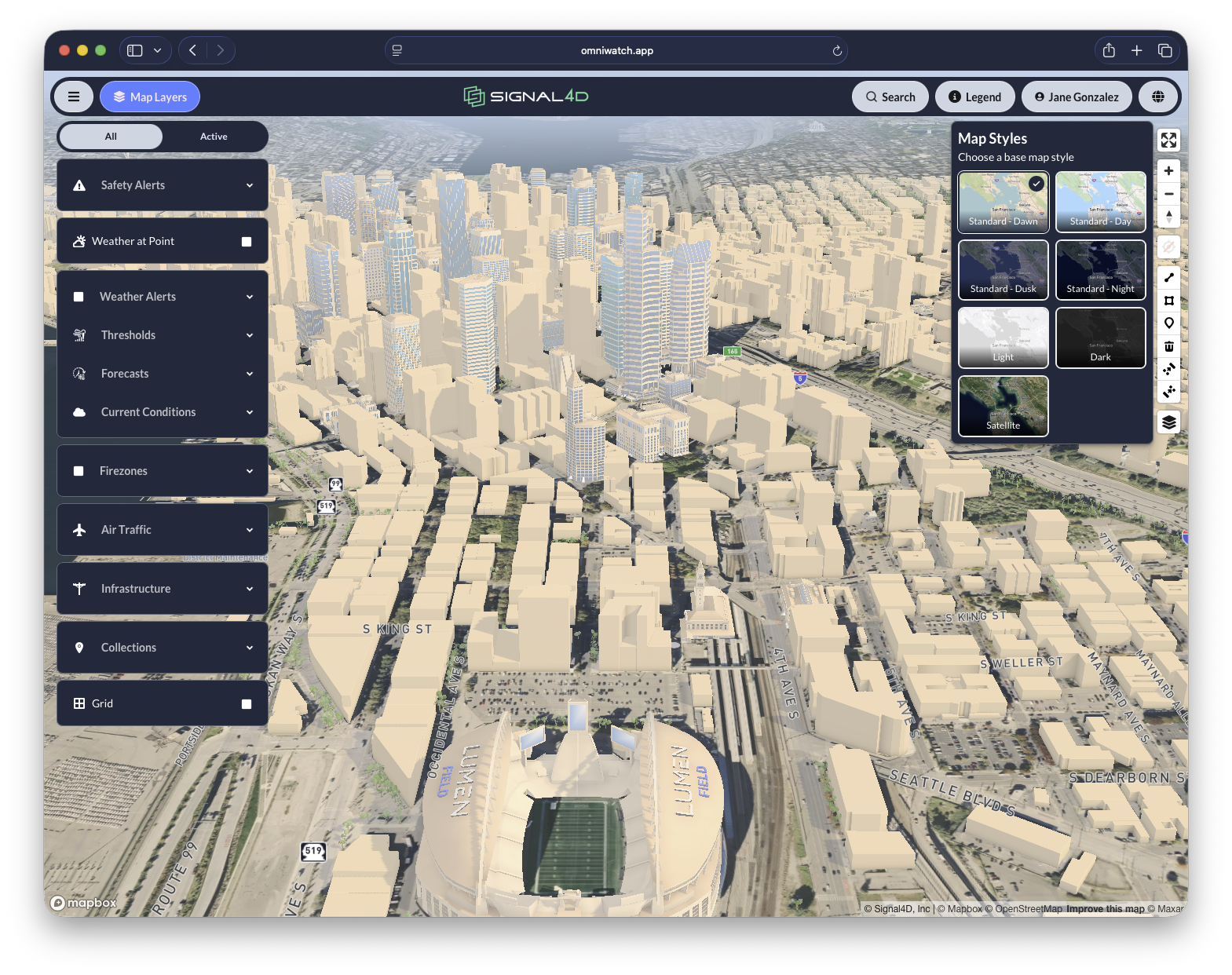
OmniWatch — the app
A ready-to-use, configurable operating picture for your whole organization. Secure sign-in, role-based access, localization and per-user settings — nothing to build.
Take the tourDevelopers & APIs
An API-first platform — ingest assets, pull global weather and hazard data, configure thresholds, receive webhooks, or embed OmniWatch in your own product.
Explore the APIsEnvironmental Data Fusion
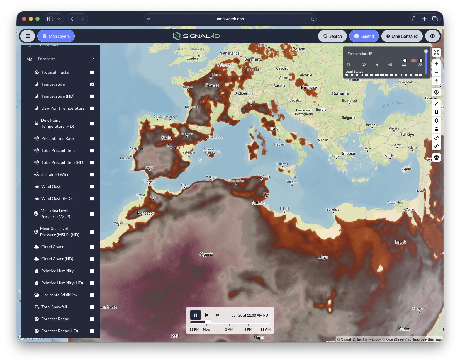
We ingest and harmonize best-of-breed global environmental data — current conditions and forecast — so you have access to the most relevant and integrated data available.
- Weather models, local stations and surface observations
- Radar — continental, regional and single-site super-resolution
- Global lightning strikes and density
- Storm tracks, cells and severe-storm prediction
- Satellite hot spots, fire and agency fire data
- Government weather alerts, hail, flood and air quality
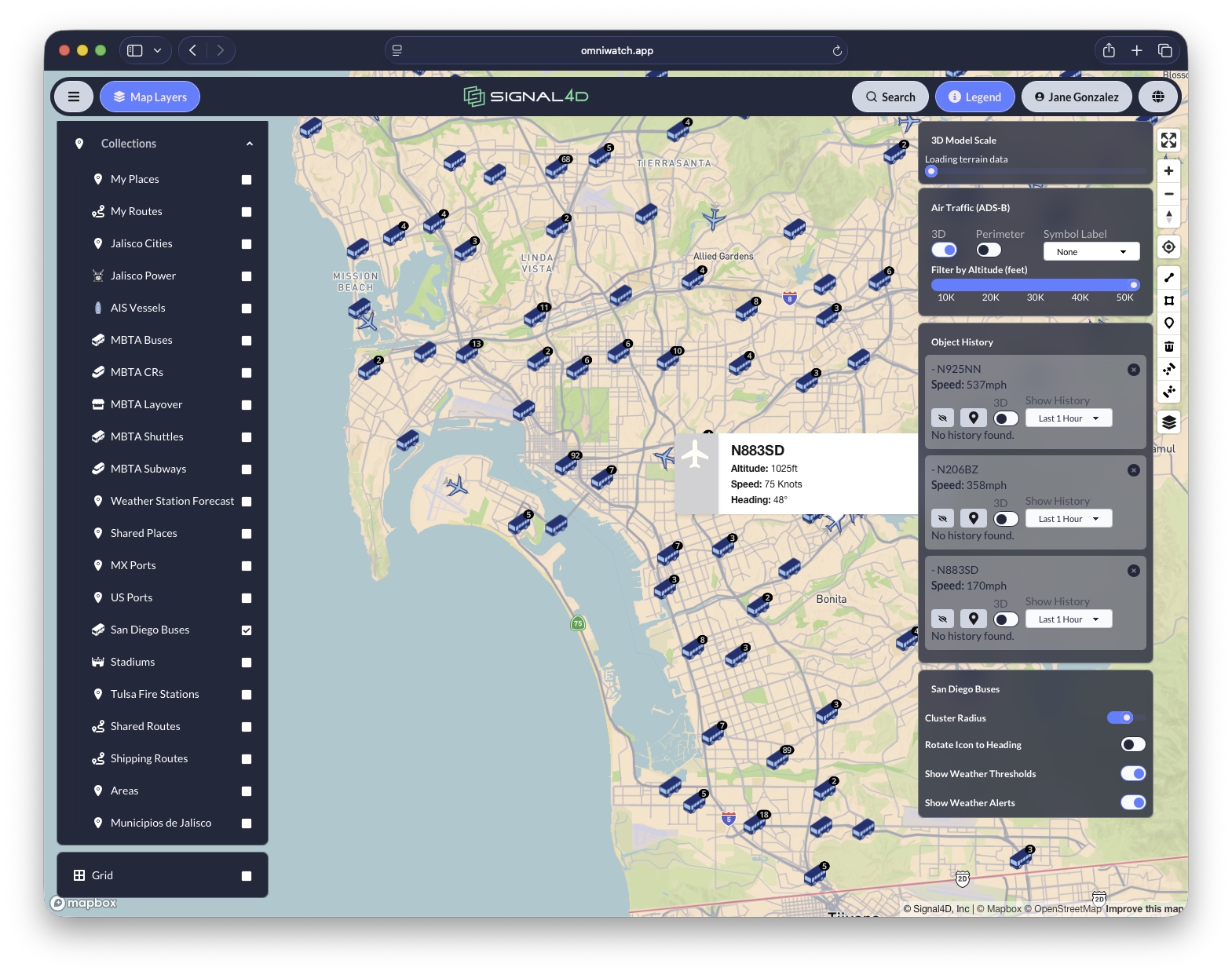
Asset & Infrastructure Modeling
Open APIs ingest your static and moving assets so the map reflects what you actually operate — not just the weather.
- Moving assets updated live by telemetry — fleets, vehicles, vessels, aircraft, drones and personnel
- Static assets: plants, substations, power lines, pipelines
- Networks: supply lines, trucking routes, distribution centers, ports
- Land: forested holdings, parcels and service territories
- Store and replay full history paths
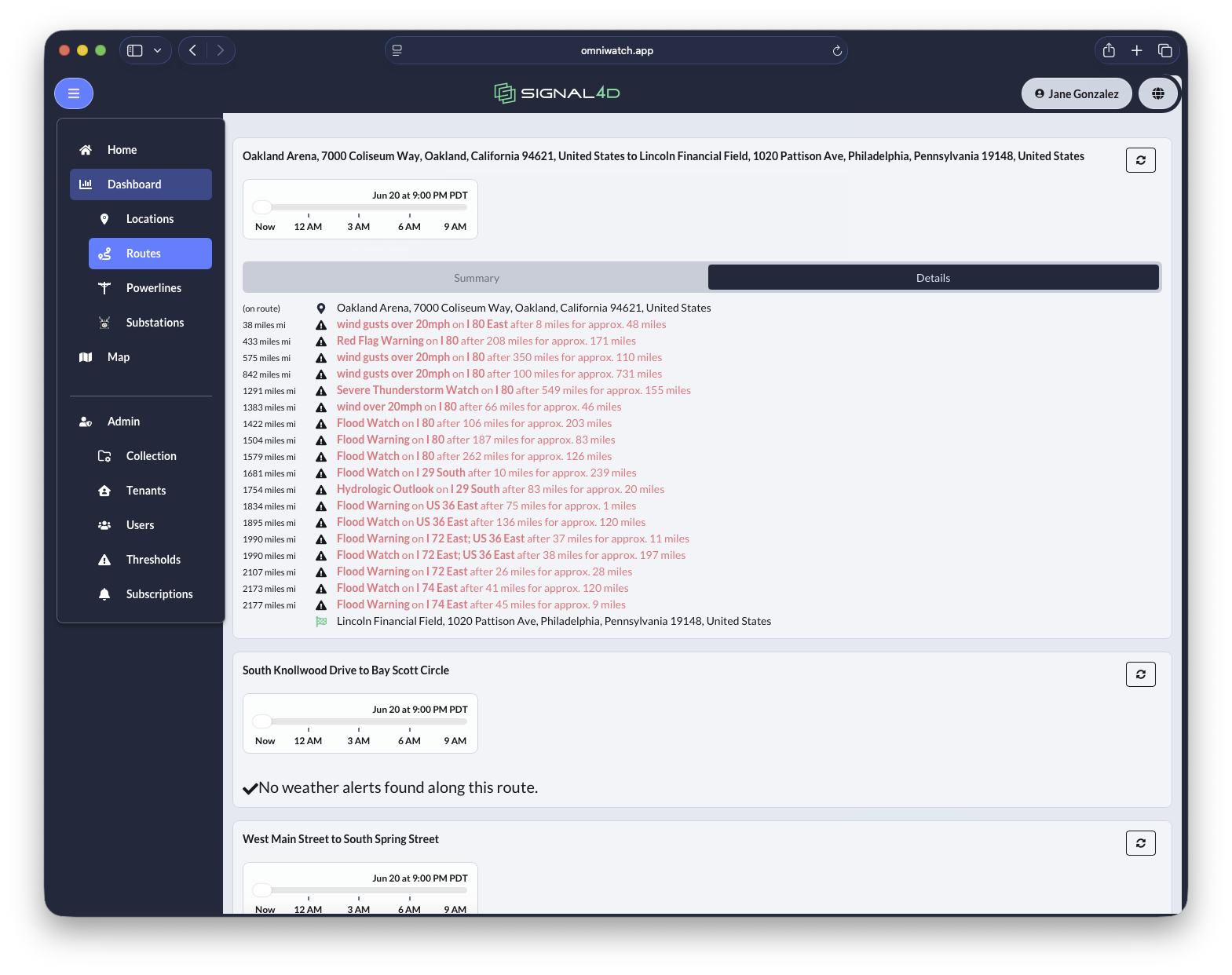
Impact Intelligence
We overlay the environment onto your assets to compute current and forecast impact, down to the specific segment, asset, location and timing.
- Which power-line segment, which vehicle, which facility
- Specific locations with timing — now and ahead
- Risk profiles for infrastructure and assets
- Historical and predictive analytics and modeling
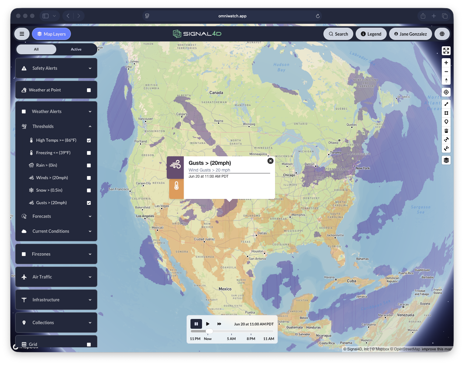
Compound, Multi-Source Alerting
Alert only when the conditions that matter actually align. Because Signal4D fuses many sources into one picture, it can combine them into a single, high-confidence alert.
- Multi-condition logic (e.g. high temperature AND high wind on a line)
- Compound events (red-flag warning + lightning + satellite hot-spot near an asset)
- Custom thresholds per asset, route or territory
- Dynamic monitoring zones — drawn by users or generated automatically as conditions evolve
- Delivered via interactive map, dashboard, email, SMS and mobile
Common Operating Picture
A shared, role-based view from the operations center to the field — configurable, secure, and built to embed.
- Deployed enterprise-wide: ops center, desktop and field
- Role-based access and tenant management
- Integrate GIS, asset-lifecycle and fleet-telemetry systems
- Consolidate enterprise IoT: weather stations, cameras, drone sensors
- Developer portal and APIs for programmatic integration and embedding
An extensible platform, not a static dashboard.
Signal4D doesn’t stop at the alert. Create events, notify the right teams, launch a drone for verification, stream live video into the picture, and coordinate the response — all in one place.
Built to plug into the enterprise you already run.
Custom thresholds
Set the conditions that matter per asset, route or territory.
Enterprise & user access
Role-based access and tenant management across the organization.
Enterprise integrations
Connect GIS, asset-lifecycle and fleet-telemetry systems.
Consolidate IoT
Bring in weather stations, radar, fixed cameras and drone sensor data.
Most weather tools stop at the forecast. Signal4D delivers the whole operating picture.
A great forecast tells you what the weather will do. Signal4D tells you what it will do to your operation — your assets, your routes, your people — and across every hazard, not just the sky.
We aggregate the world’s best environmental data — so you don’t have to.
Signal4D isn’t locked to a single model. We unify many global, best-of-breed sources — weather and forecast models, radar, lightning, satellite, surface observations, government alerts, fire and traffic — with full source attribution.
That includes data from close partners like Spire, whose global satellite weather observations extend coverage to the open oceans and remote regions other networks miss.
See risk earlier. Understand impact faster. Act with confidence.
See how the platform maps onto your assets, your data and your decisions.